African Kings and World Trade. State Formations and Trade Patterns in pre-colonial South-East Africa

And their relation to the Indian Ocean Rim before the arrival of the Europeans


Anthology, 1999

259 Pages, Grade: 2,0


Excerpt


CONTENTS

List of Maps and Figures

0. Some Personal Remarks

1. Introduction
1.1. The Role of Archaeology, History and Ethno-History in the context of the Southern African Region
1.2. The Geographical Introduction - Boundaries of the Area and Geography behind the History
1.3. The Periods under Consideration in the Context of the Region

2. Archaeology of the Region: Sources, Methods and Results
2.1. The Development of Archaeological Research with particular Reference to Great Zimbabwe
2.2. Archaeological Findings at Mapungubwe and Bambandyanalo
2.3. The Leopard's Kopje Tradition
2.4. Ingombe Ilede
2.5. Manekweni
2.6. Khami Ruins and Dhlo Dhlo
2.7. Further Related Sites
2.8. The Early Portuguese Period
2.9. The Current State of Research. New Questions and Approaches
2.10. Some Hypotheses put forward by Archaeologists on the Society and State Formation of the Great Zimbabwe Culture
2.10.1. Predominance of Politico-Religious Symbolism
2.10.2. Pastoralism
2.10.3. The Trade Hypothesis
2.10.4. The Initiation Interpretation
2.10.5. Reasons for the Fall of Great Zimbabwe
2.11. Some Remarks on the Current Scientific Debate and some Conclusions from Archaeological Results

Appendix: Radiocarbon Dates

3. Documentary History of South Eastern Africa with Special Reference to Arab and Early Portuguese Sources
3.1. Available Arab Documentary Sources
3.2. Some Conclusive Remarks on the Evidence from Arab Sources
3.3. Portuguese Reports on the Interior and their Impact on Historiography
3.3.1. The very early Portuguese Contact
3.3.2. Portuguese Writings of the second half of the Sixteenth and in most of the Seventeenth Century
3.3.3. Later Portuguese Writings with Special Reference to the Changamire
3.4. Some Conclusive Remarks on the Documentary History

4. Ethno-History of Zimbabwe and Mozambique - Oral Tradition as History
4.1. Special Problems of Methodology of Ethno-History in the Region
4.2. The Discovery of Maramuca through the Combination of Oral Tradition and Portuguese Documents
4.3. The Contribution of Oral Tradition to the Rozvi- Question and the Problem of the Abandonment of Great Zimbabwe
4.4. The Development of the Term "Shona" , the Linguistic Affinities of Modern Shona and their Importance to the Exploration of Historical Developments

5. Preliminary Conclusions from a Synthesis of the Findings of Archaeology, Documentary and Ethno-History in Zimbabwe and Adjacent Areas - Summary and Outlook

Notes to Chapters 1-5

Sources of Maps and Figures

List of Maps and Figures

I.

II. Physiography

III. Mean Annual Precipitation

IV. The General Setting of the Research Area in Africa

V. Tsetse Distribution

VI. Principal Sites

VII. The Site of Great Zimbabwe

VIII. The Zimbabwe Birds

IX. The Great Enclosure

X. Great Zimbabwe - Stone structures and huts

XI. Later Iron Age Southern Africa

XII. Location of Great Zimbabwe Sites

XIII. Distribution of Zimbabwe and Khami Styles Sites

XIV. Maund Ruin

XV. Mambo and Bambandyanalo

XVI. Nunghuza Main Hut

XVII. Ancient Gold Workings

XVIII. Khami Ruins

XIX. Great Enclosure Wall

XX. The Suaheli Corridor

XXI. Map of Rudbeckius, 1610

XXII. Map of Senex, 1720

XXIII. The Mutapa Empire, c.1480 and c. 1514

XXIV. The Rozvi Confederacy c.1700

XXV. South East Africa, 16th and 17th century

XXVI. Hakata

XXVII. Portuguese Records and Oral History

XXVIII.Ethnic Groups of Zimbabwe

XXIX. Reconstruction of the Platform of Great Zimbabwe

0. Some Personal Remarks

The author of this essay has had the opportunity to visit Zimbabwe and neighbouring countries on several occasions in the eighties and nineties and each time visited some of the important archaeological monuments. There was always ample time for discussions with modern Zimbabweans about their cultural heritage and to acquire literature which is otherwise inaccessible in Europe.

The way Zimbabweans went about their history was very enlightening and with some regret the author found that European historians do not focus enough attention towards that contested region of the world. Nevertheless this essay is only a seminar paper and admittedly suffers from the lack of field work. The author considers himself to be more of a historian apprentice and has no archaeological field experience. But in the course of work on early Zimbabwean history the need was felt to combine the results of archaeology with those of the classical history and - another important factor in African historiography - with a well-understood oral tradition. The conclusions in this paper are often very theoretical. But why should African history not be considered from a philosophical-theoretical aspect? This could actually be a fertile confrontation for both sides.

Facts and findings could not be tested in the field, but are only quoted from the research work of people who invested sometimes major parts of their lifetime work into the investigation of Zimbabwean history. Whenever these works are screened critically it happens with much respect for that work. The most impressive work has certainly been done by Peter Garlake. The author was very honoured to discuss some problems with that great old man of Zimbabwean archaeology. Special thanks go also to members of the Zimbabwe Council of Churches, Christian Care and the Jairos Jiri Association who hosted me during my travels to Zimbabwe, guided me and gave me inspiration.

Travels to Mozambique were made during a cruel war situation and there was not much room to talk about history. Basic needs of survival were often more important. But it is clear that Mozambique, once peace is restored, will be a rich ground for research. Other countries visited - as far as they are of interest in this context - were Botswana, Malawi, Zambia, Tanzania, Kenya and Angola, so practically all Frontline States.

Once having travelled in this region it is obvious that one has to confess on which side of the liberation struggle of the African peoples against white supremacy and destabilisation one stands. The author has always supported African liberation movements in their struggle. That sympathy goes back to the early seventies when the liberation struggle was in full power and the leader of the liberation forces of Zimbabwe was barred from entering Germany for reasons of being a “terrorist”. My African friends paid back my solidarity with a warm welcome and enormous support.

1. Introduction

1.1. The Role of Archaeology, History and Ethno-History in the context of the Southern African Region

The history of Zimbabwe as a complex African culture is still in the making. At present it is still something like a jigsaw puzzle to put together the findings of archaeology, written and oral tradition. Quite naturally the writing of Zimbabwean history is accompanied by a number of controversies. But this debate can be rather fruitful and in the end become a major contribution to the historical sciences as a whole, not only of South East Africa but worldwide.

On the other hand it has to be taken into account that the progress of scientific historical research on Zimbabwe has been tremendously hampered by the ideological predominance of the specific South African version of racialism for nearly a century. One of the ideological bastions of white minority rule in Southern Africa is the prerequisite that Africans are not in a position to have their own cultural and historical contribution to the development of mankind, i.e. a history as such.

Hand in glove with that ridiculous prejudice enormous damage has been done to the national heritage of the Africans by grave robbers and treasure hunters. "The behaviour of such men showed the lack of regard Europeans had for African culture and history. The idea that Africans possessed cultural values and a civilisation independent of European culture was either inconceivable or suppressed as a threat to their own plans. This attitude was “... demonstrated in 1970 when the Rhodesian Front regime instructed that no official publications should state that Great Zimbabwe was without doubt an African creation."(1)

Given these circumstances the break-through of scientific historical research was bound to have an emancipatory impetus towards the re-occupation of African cultural heritage by Africans also in the field of cultural sciences. It was the special contribution of archaeology which led to the birth of the idea of a new state of Zimbabwe as conscious continuation of the cultural and material heritage centering around the ancient Great Zimbabwe. Archaeology destroyed the legend that the impressive monuments in the country were the products of unknown foreign rulers and had nothing to do with the local African population.

Written history was not in a position to play such a progressive role in the past as it could not, for a long time, go beyond the descriptions of the old Portuguese sources and decipher the intrinsic messages of oral tradition which were contained in the Portuguese descriptions and reports all being written under only one line of interest : the hunt for gold. The Portuguese themselves relied on the narrations of all sorts of people and it is still very difficult to differentiate between the realities of the time and mere hearsay. There is a great number of oral tradition reports collected by the National Archives in Harare but unfortunately these have only been published in small dosages and are otherwise not easily accessible.

With this constellation of research it is not very surprising that the archaeologists of the region have slipped into the role of general historians . It is only since the independence of Mozambique 1975 and of Zimbabwe 1980 that history, archaeology and ethnological field research can work freely, though limited by scarce economic funds and - for some years now in Mozambique - by banditry and civil war in the countryside. Despite these difficulties we do find here a close combination of all three sciences which is so far not known at European universities. The object of research, African history itself, forces the archaeologist to master historical and ethnological methods and vice versa. For the European observer this is rather enlightening in view of some tendencies here in old Europe to unify these approaches in the European field of research, too, where we have now the archaeologist digging his way through to the contemporary layer or the historian taking to oral tradition in finding a 'history from below'.

1.2. The Geographical Introduction - Boundaries of the Area and the Geography behind the History

Naturally the geographical limit of the area we focus our attention on exceeds the boundaries of the present-day Republic of Zimbabwe. Like anywhere else in Africa these boundaries are not a result of any form of an earlier agreement between African peoples, but have been created by colonial powers during the 'scramble for Africa'. Despite of this fact modern Zimbabwe is rather homogenous in her ethnical composition, unlike many other African countries of today. The vast majority of the inhabitants is formed by the Shona. And even the second largest group, the Ndebele, had longstanding relations with the Shona long before the advent of colonialism - even though these relations were partly of a violent nature.

On the other hand the division of Africa amongst the colonial powers - in this case especially Britain and Portugal - split the territory of the Shona . A big proportion of Mozambique's (2) central belt is inhabited by Shona and certainly this coastal area must not be left out in any historical analysis of the region. So we will have to include this part of Mozambique up to the shores of the Indian Ocean in the East.

In the North the Zambezi river forms something like a cultural boundary - even though not consistently sealing off both banks. We have the Tonga on the south bank of the stream for a long time in history while their majority settles in Zambia. This river had an important function as trading route and therefore rather linked than divided the peoples north and south. A strong cultural similarity has been found between the ancient Zimbabwe and Maravi states (3). Nevertheless we can take the Zambezi as an orientation line on the northern side.

To the West we have the Kalahari. There is no fixed frontier of this dry savanna and consequently no clear cultural division between peoples inside and outside the Kalahari, especially its southern part, where migrations have taken place until the present times.

As to the south we can take the Limpopo river, but also here it is quite clear that the river was more a link than a division. Archaeology has shown that there are cultural influences south of the Limpopo which could have substantially determined the development of the Zimbabwean cultures. On top of that we find here also ethnic groups which are closely related - if not identical - with groups inside Zimbabwe: the Venda, the Tsonga, the (South) Ndebele.

Summing up it becomes quite clear that we have to differentiate between what is he modern Republic of Zimbabwe and the ancient cultural complex which is called after the remarkable ruin site: Great Zimbabwe(4). Bearing this in mind we must not neglect the long-distance relationships that existed towards the Suahili corridor (5) and possibly other regions . This brings us right into the middle of the historical debate on questions like outside influence, migration theories, the character of the Great Zimbabwe culture in general.

Coming back to the geomorphology of the area we have to consider one important fact: the heartland of the region is formed by a vast highland which is climatically pleasant, in winter sometimes even a little chilly and - most important - free of the infestations of the lowlands, especially free of the tse-tse fly. Both , Highveld and Lowveld, depend

Abbildung in dieser Leseprobe nicht enthalten

largely on sufficient rainfall, the hot and dry lowland areas of course even more so. The amount of precipitation during the rainy season decides largely over the forthcoming harvest and with that over the economic well-being of the society and the individual. The dependence on rain is still a feature of modern Zimbabwe and it is very obvious that this was a constituent element of any sort of cult which could come into existence here. Another factor is that the combination of rainfall and height turns the Highveld into an abundant grazing land whereas in the Lowveld all forms of agriculture are much more difficult and vulnerable.

Abbildung in dieser Leseprobe nicht enthalten

1.3. The Periods under Consideration in the Context of the Region

The drawing of precise time limits for this essay is as difficult as the construction of limits in geographical space. Too much intertwined are the historical periods of development , too little do we already know to make clear distinctions between different periods. But a few things can be taken as facts: First of all and against the impression of the first glance, the Great Zimbabwe culture did not come into existence abruptly, neither did it disappear at a sudden. Great Zimbabwe is embedded in historical processes of the regions which fill centuries.

Abbildung in dieser Leseprobe nicht enthalten

Even though it is more than fascinating we want to leave out the whole period of the 'Stone Age'(6). The same applies to the period of the 'Early Iron Age'(6). A discussion of the results of their archaeology could fill a compendium, but it would not bring us near the central topic of this essay: the comparison of results of archaeology, documentary and oral history. Therefore we will set the beginning of the period we are going to cover in this discussion at approximately the eighth or ninth century A.D.

At the other end of the time scale the results of the Mfecane, respectively Difaqane revolution in Southern Africa created a thorough disruption of societal development

Abbildung in dieser Leseprobe nicht enthalten

also in the area north of the Limpopo and even far beyond. This period at the beginning of the 19th century creates a clear mark in history with the advent of the Ndebele in the Land between Limpopo and Zambezi.

But even before that the power of the states of the area was slowly fading out. We will therefore stop more or less with the late 18th century already. The analysis of the state of affairs at the arrival of the Ndebele would be another story altogether.

We will focus on those fields of research where archaeology, conventional and oral history overlap or at least come rather close to each other. As already stated these seem to be the most inspiring areas of discussion which could give some very interesting impulses to the debate on historical theory in general.

2. Archaeology of the Region: Sources, Methods and Results

After a century of white supremacy the tide is turning in Southern Africa. This involves the enormous task of re-writing a large part of the history of this part of Africa. The role of archaeology in this process cannot be underestimated.

Practically all recent publications on the general history of Southern Africa refer to the findings of archaeologists before proceeding with what is traditionally understood as (documentary) history. This applies to advanced school books (1) for the region, especially publications used in Zimbabwe (2). Due to political reasons the archaeological aspect of early African presence in the region is dynamite to the white supremacy ideology. Therefore prehistorical research could not advance so much in the Republic of South Africa itself and is not so much prevalent in publications concentrating more or less exclusively on South African history (3). In texts on the history of the already independent states of southern and central Africa the results of archaeology form an important part of historiography and also allow interesting comparisons with other equally developed cultures on the territories of present Malawi, Zambia and other countries(4).

In Zimbabwe itself the 'Iron Age' has been rapidly and proudly incorporated into the new historiography without asking much about the traditional differences in the European schools of thought between the old disciplines of archaeology and documentary history as such. It all runs under 'national heritage' - and quite rightly so (5). Naturally, for the purposes of field visits of interested people (not to forget the important income source of tourism) a number of well-made trail guides have been published, mainly by the National Museums and Monuments of Zimbabwe (6).

2.1.The Development of Archaeological Research with particular Reference to Great Zimbabwe

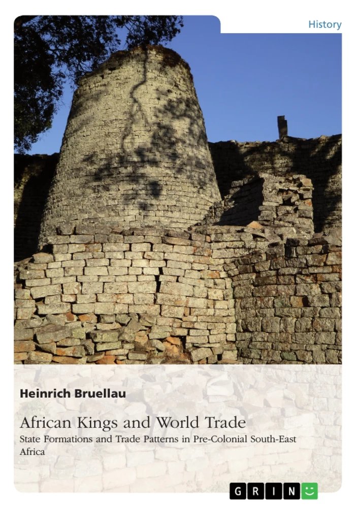
The discussion of the early perception of European researchers on 'mysterious' origins of the Great Zimbabwe and related cultures shall only be mentioned briefly. It is true that in colonial times there was many a pseudo-historian who tried to prove that Great Zimbabwe was not of African origin or that it had at least no link to the present African population of the country. The purpose of these racialist theories is simply an attempt to deny the rights of the original inhabitants of the land. They have been dealt with enough. Any further discussion would mean nothing else than shadow-boxing. It is much more interesting to concentrate on the progress of scientific

Abbildung in dieser Leseprobe nicht enthalten

VII. The site of Great Zimbabwe

archaeology and to see what conclusions have been drawn out of the material findings of the excavations. The impressive nature of the stone buildings of Great Zimbabwe(7) makes it necessary to focus the first attention in the discussion on the results of research into that particular site.

"The site Great Zimbabwe covers over 720 ha and comprises mainly stone wall enclosures and areas of hut remains. ... The stone walls, up to 6 m thick and 11 m high, are built of granite blocks without the use of mortar. Natural granite boulders are often incorporated into a wall which usually follows a curved line. The purpose of the walls was primarily to enclose areas within which 'dhaka' (clay) structures and smaller partition walls were constructed."(8) The builders made use of the natural source of granite split in slabs and easily available locally. "The earliest 'undressed' masonry, dated to the 13th century, is built from these slabs; the 14th century masonry is composed of 'dressed' blocks deliberately chipped to the required shape and size. The junctions of the walls are not bonded together; instead, each wall leans slightly against another. Inside the enclosures there is evidence that some of the walls and ground surfaces were originally plastered with 'dhaka'". At the Hill Complex, measuring roughly 100 m by 45 m, many of the walls "date to the earliest building style and it has been suggested that the Hill Complex was probably always the main spiritual and religious centre of Great Zimbabwe". "Small scale excavations in 1958 in the peripheral area revealed that there was continuous occupation in the enclosure for about 300 years. The accumulated stratigraphy showed that when old huts were destroyed the remains were levelled off and new huts built on top. Ceremonial spearheads, large soapstone bowls and gold objects were amongst the items found in here ... . At least 30 granite and soapstone monoliths were found in this enclosure, some of which were decorated with geometric designs and six of which were carved in the stylised shape of birds now known as the Zimbabwe Birds" (8).

The Great Enclosure is the largest stone structure south of the Sahara. The perimeter wall is 250 m in circumference and 11 m high, and it is estimated that nearly a million granite blocks were used in its construction. The roughly oval-shaped structure encloses an area 80 m by 55 m and contains a number of stone features, including the Conical Tower. ... Two high walls form the narrow parallel passage, 55 m long, that allows direct access from the north entrance of the enclosure to the Conical Tower. The inner wall of this passage was originally built as the perimeter wall; the massive outer wall was constructed later, surmounted by monoliths and decorated with two courses of chevron pattern high up on the external face of the Conical Tower. The Conical Tower, one of the last structures to be built in the Great Enclosure, is 10 m high and 5 m in diameter at the base, tapering to 2 m at the top where, originally, there were an additional three courses of 'dentelle' decoration. ... Its large size and seclusion behind an equally massive enclosure wall, together with the narrow passage- way leading to it, indicate that it was an important structure. ... The remains of stepped platforms and hut floors are found inside the Great Enclosure..."(8).

In the so-called Valley Enclosures there were an estimated 50 households. "Within them ... are the remains of 'dhaka' huts, platforms and small towers. The seventh Zimbabwe Bird ... was found in one of these Enclosures; in another enclosure a large hoard of iron and copper objects, beads and pottery was found. Many of these enclosure walls are built in the later style of walling, suggesting that the town layout in the valley changed with time ... . Celedon pottery from early in the period of the Chinese Ming Dynasty (1384 - 1644) is one of the most frequent imports found at Great Zimbabwe." Of interest is also the fact that "most of the animal bones from the rubbish heaps of the stone enclosures are those of young adult cattle, suggesting that this was an important source of meat for the inhabitants" (8). There is no archaeological evidence so far that gold trade was a major factor for the foundation of Great Zimbabwe. "Most gold ...has been recovered from the upper levels of archaeological deposits, indicating that gold was most prevailing well after the establishment of the town "(8). At the arrival of the whites at the site, the area was inhabited by people of Mugabe's clan who treated the whole area with great respect. They and their predecessors certainly left their cultural remains as top layers on what was left of the foregoing periods.

The first European to see the ruins in modern times was the German geologist Karl. Mauch, in September 1871. He was fascinated, but from his diary notes no conclusions for any dating can be drawn. "Auf dem Gange zurück besah ich noch, was ich als Vorwerk ansehe, und fand einen Gegenstand von der beigegebenen Form aus Eisen,… Es sind 2 dreikantige Hülsen, durch eiserne Bögen miteinander verbunden."(9) (On the corridor looking back I saw something like a buttress and found an object in a certain form made of iron…. There are two three-sided casings linked to another by iron brackets. HB). No hint of any stratigraphy, not even of the approximate location of this important find is given. It appears as if this artefact simply lay around on the surface. In spite of those unclear circumstances of the spotting of what was later called the 'king's bells' they have been quite uncritically dated by Fagan (10) and this judgement accepted by Vansina. "South of the forest, the earliest double bell so far is the one from Zimbabwe, dated roughly to A.D.1450/1500."(11)

After the colonisation of the country, which was then called Rhodesia, it was quickly realised by the occupiers that the ruin sites contained a number of treasures. For 10 or 15 years the ruins were ransacked by fortune-hunters. Exploitation went so far as to the creation of a company called "Ancient Ruins Company" which dedicated itself to the commercial exploitation especially of the gold finds in the ruins. It is a tragedy that so much possible archaeological evidence was destroyed in the first decades after the arrival of the white usurpers in the country.

In a first treasure hunt 42,5 kgs of gold were discovered "consisting of necklaces, rings, tacks, nails, chains, beads and mountings for furniture beaten out of solid gold" without disclosing where this haul was made. Certainly walls were torn down, graves undug, stripping skeletal remains of jewellery. "These grave robbers noticed that the custom seemed to be to ornament furniture with sheets of beaten gold nailed on with golden tacks. Corpses were found with what appeared to be wooden pillows (mitsago) overlaid with beaten sheets of leaf gold nailed on with pure gold tacks." (12) These destructive activities went on from 1895 to 1903 when the company was wound up. They must have got some hundred pounds of gold before the dissolution of the enterprise. But also people like Rhodes himself felt free to collect artefacts from the ruins and to acquire them as private collection property.

The Ancient Ruins Company had also searched Chumnungwa, the largest ruin site of the Great Zimbabwe style in Matabeleland, with upto 5 m high walls. "They found seven burial sites containing gold jewellery and other items. They also found an iron gong, a copper ingot cross and two soapstone dishes ... like those found at Great Zimbabwe."(13)

No less detrimental were the first excavations like that of Hall who simply shoveled out a layer of several feet of soil from the Great Enclosure thus destroying any possible stratigraphy for later archaeologists. In all discussions on the results of excavations we must take into account these enormous destructions caused by blank robbery and unselective and uninformed digging.

The first big step forward in Zimbabwean archaeology was made by Gertrude Caton-Thompson. The interest so far rested with imported material, gold hoards and the ruin walls themselves. Caton-Thompson set out to systematise these eclectic impressions by careful stratigraphy. She selected a site in the Valley of Ruins, the so-called Maund ruins at Great Zimbabwe with the objective to "check the exact relationship between the lowest occupation layers (beneath the original cement floors) to the main walls of the buildings " (14).

She found an occupation layer as the lowest stratum resting on virgin soil and forming the very foundation upon the builders based their walls. As this lowest stratum was sealed by an intact cement floor all objects found were in situ and therefore constitute remnants of the original builders' occupation of the site. These findings brought Caton-Thompson to two important conclusions:

"1. No case can be established for an occupation earlier than the building period." and "2.The objects of this period excavated from a sealed deposit include iron weapons, spearheads, arrowheads and an axe, also bronze wire bangles " which she interpreted as all "typically Bantu in character"(15).

In further test diggings a midden was laid bare inside the so-called Acropolis (Hill Complex) and an extensive series of test trenches was dug outside the girdle wall. Finally a tunnel was driven under the famous Conical Tower right through from one side to the other. Apart from the fact that this last test produced undebatable evidence that this mysterious building was n o t the superstructure of a grave the result was again the same. Further excavations examined the Matindere and Mshosho ruins, the fortified kopje of Chiwona, Chibvumani - where similar to Great Zimbabwe imported glass beads were found in the oldest bed-rock stratum. Finally , at the site of Dhlo-Dhlo (16), a burnt hut was found with surprisingly intact contents , including a Ming bowl (12th to 16th century). Caton-Thompson concluded: “All that may with reasonable regard for the probabilities be said on the existing evidence is that the building of stone structures in Southern Rhodesia...appears to cover a period of considerable length; the earliest cannot on any available archaeological evidence be placed as earlier than the 10th cent. and may be any amount later; and that the latest cannot, on any available archaeological evidence be placed as earlier than the Ming period, 12th cent., and may be - and almost certainly are - as late as the 16th. cent."(17)

It is the great merit of Caton-Thompson that with this examinations she dealt the final blow to all legends of Semitic or Oriental origin of the ruins and that was quite obviously the guiding line of interest of her work in what was then Southern Rhodesia. What is not reflected by her is the amazing fact that the occupants of Great Zimbabwe started building huge stone wall constructions more or less right from the beginning of that settlement there and that they had far-reaching trading connections already when they were supposed to have started building the stone constructions. Construction works and any form of trading exchange means quite logically a heavy form of social investment of labour - apart from the division of labour and know-how necessary - and therefore some form of development up to that point must have taken place in that society - even though not necessarily at the same site.

With regards to the position of Great Zimbabwe in time and space, Caton-Thompson came to the conclusion that the perfected building at Zimbabwe stands at the beginning of a sequence not at the end. "The time scale in Rhodesia's case leads ... away from the best towards deterioration and not from immaturity to maturity."(18) This assumption somehow reveals – in spite the scientific merits of her work - a totally misconceived and prejudiced attitude towards the development of African societies in general and towards the contemporary inhabitants of the country in particular. Nevertheless, her examination remained for decades the only solid source of proof for African origin in the discussions on Great Zimbabwe.

From the findings of Caton-Thompson it is obvious that this development did not take place at the site of Great Zimbabwe itself but probably somewhere in the region. The occupants of Great Zimbabwe must have brought with them the knowledge of stone-building and also their trading relations. The culture we find at Great Zimbabwe is quite obviously a highlight of societal developments which took place in the region, perhaps some centuries before the site itself was occupied. Obviously the history of Great Zimbabwe is embedded in the overall historical process which took place within the whole geographical area.

In the mid-fifties Whitty, in a study on the architectural peculiarities of Great Zimbabwe came to the conclusion that

"1. the characteristic architectural techniques and forms are so consistent and clearly defined as to presuppose an early period of formulation, development and crystallization.

2. the characteristics are generally peculiar to Zimbabwe and its satellite sites and cannot be accounted as originating from any culture within possible reach of the builders."(19)

Abbildung in dieser Leseprobe nicht enthalten

He therefore demands quite rightly the we are "faced with a highly specialized architecture ... for which some sort of evolutionary background must be found."(20)

The debate on Great Zimbabwe gained new momentum with the *introduction of C-14 tests. Some pieces of wood were found in Drain 7 leading from the interior of Enclosure 14 to the Parallel Passage between the Inner Wall and the Great Outer Wall. Various examinations confirmed that it was in situ. The wood "had been inserted when the wall was built to carry the weight of the wall where it crossed an opening about 3 feet wide in the wall foundations. They were in effect wooden lintels carrying the wall above a drain."(21) The wood was identified as 'ubande' with the biological name of 'Spirostachys Africana Sond'. It is exceptionally hard, ant-proof and decays very slowly, the nearest known occurrence nowadays being 30 miles away from the Great Zimbabwe site. Using the opportunity a section was laid through the drain and sump and its underground. Below the floor of the sump a layer was detected with debris containing "Wall stones, earth, old hut daga, sherds, some carbonized wood (piece of post)" and "soapstone fragments" (22). Summers therefore concluded that the presence in that particular stratum 2 of wall stones and of "charred logs and fragments from the walls of mud huts shows that there were stone walls and pole-and-daga huts before the drain was built"(23) and - we should add - before (this part of) the Inner Wall was built. The pottery sherds , both above and below of the sump floor, were of the same class.

From these finds we can already come to a much different conclusion from that of Caton-Thompson. Quite obviously there were several periods of construction and the massive walls we see today have been built at least partly on the debris of foregoing constructions. Unfortunately discussion did not go deeper into that problem but focused on the sensational results of the C-14 tests which were carried out with the pieces of timber, both in London and Chicago. Their results were amazing and overthrew any theory on the age of the ruins so far put forward. The two tests came to the following - shortened - results:

Zimbabwe I (Chicago) = A.D.591 (+./.120)

Zimbabwe II (Chicago and London) = A.D.702 (+./. 92). (24)

These results were uncritically hailed by historians worldwide as they inspired imagination; "la civilisation de cette derniere cite est bien plus ancienne qu'on ne l'a imagine."(25) (the civilization of the latter city is very much older than so far imagined. HB).

It was quite clear that the above dates did not at all coincide with the age of the imported material that Caton-Thompson had found. Further radiocarbon dates taken from samples from the Hill Complex showed an age of not before AD 1100. (26) By about 1971 more than 50 radiocarbon dates for the Iron Age of the country were available and the period of the building was further compressed to between AD 1200 and AD 1450. Therefore it was about time to re-test the lintels from Drain 7. Remaining portions were dated in Pretoria in 1979. the results were as follows:

"Pta-792 Zimbabwe Lintel I 650 +./. 50 bp 1300 ad ...

Pta-1594 Zimbabwe Lintel II 620 +./. 40 bp 1330 ad ".

Another lintel from the Acropolis was also tested:

"Pta-1192 Zimbabwe Lintel III 640 +./. 50 bp 1310 ad".(27)

Finally a major inconsistency was eliminated. A fourteenth century confirmation for the walls which contained the lintels was firmly established!

To go further into detail it will be necessary to differentiate between the wall building styles of Great Zimbabwe. The two main styles are generally called P and Q and described as follows:

"(a) 'P walling': The stone blocks are irregular in size and shape, and there is little or no signs of dressing of the blocks.

the courses are uneven and tend to fade out. ...

(b) 'Q walling': The blocks are well sized, and usually show obvious signs of having been dressed or knapped. The courses are level and continuous for many yards. ... "(28).

Abbildung in dieser Leseprobe nicht enthalten

It is generally accepted that P walling has been proved to be earlier than Q. This alone implies a development in the building styles - towards 'maturity' to use Caton-Thompson's expression in order to demonstrate the contrary of her own assumption. To summarize Caton-Thompson and Randall-MacIver introduced a classification of the stratigraphy they described:

- Class 1 pottery in hill-earth immediately on bedrock
- Class 2 pottery associated with Type A huts (pole and daga) and cattle figurines
- Class 3 pottery with Type A huts
- Class 3 pottery with Type B huts (solid daga walls and floors) first stone wall built on
- Class 4 pottery associated with huts with radiating stone walls
- Class 5 pottery overlying the others in a thin layer

In their big 1958 excavations R.Summers, K.R.Robinson and A.Whitty divided their stratigraphy into five periods:

- Period I representing Early Iron Age occupation with Class 1 pottery, ending at about 400 AD

- Period II also Early Iron Age lasting until 1100 AD with Type A huts and clay figurines and Class 2 pottery

- Period III staring immediately after that lasting till the 15th century, building of the south wall of the Western Enclosure and settlements in the Valley (Great Enclosure) walling P style, Class 3 pottery and Type B huts

- Period IV with all buildings in Q style, numerous gold finds

- Period V is not important in this context (29).

In his analysis of the role of imported ceramics in dating Garlake could shorten the above chronology. He examined a piece of elaborate earthenware (30) of Persian origin, closely similar to tiles with thirteenth century inscriptions found in two mosques in Mogadishu. Therefore this vessel is probably one of the most securely dated import objects found at Great Zimbabwe; so being thirteenth - with a little tolerance - early fourteenth century. Furthermore Garlake found the majority of sherds to be "sea-green celadons, frequently crackled, with incised floral designs and ledge rims, typical of the Lung Chuan celadons of the Ming dynasty", others were "speckled pale blue-grey celadons " being classified as "Ming celadons of a type which is found in Borneo and the Philippines, therefore made extensively for export." (31) A third argument coming in here is the fact that no traces of the Portuguese were found at Great Zimbabwe. " The Zimbabwe finds diverge utterly from the now reasonably well-known trade goods of the Portuguese fairs in the interior during the late sixteenth to early eighteenth centuries. Not a single sherd of celadon occurs in a Portuguese site, and not a single item found on these sites has been found at Zimbabwe." (32) It can therefore be assumed with full justification that Great Zimbabwe was of no more economic importance, perhaps even completely abandoned by about roughly the beginning of the sixteenth century. It had its strongest economic relations during the thirteenth to fifteenth centuries.

One of the most remarkable finds to underline that was discovered by Huffman during a salvage excavation at Great Zimbabwe in 1972 is an Arab coin. "This coin has the signature of al-Hasan bin Sulaiman on the obverse", one of two sultans of Kilwa of this name, "but only the second one (c.1320-33) is thought to have minted any coins." (33)

In the further discussion Periods III and IV were merged. There was no evidence of a disturbance of occupation with only minor, gradual changes in pottery and the transition to Q style in wall building.(34) The differences between Class 3 and 4 pottery were considered as products of an evolutionary process, whereas between Class 2 and 3 an absolute break in 3 could be stated. This coincides with the replacement of Type A huts by Type B ones and the beginning of stone wall building at the opening phase of Period III/IV. (35) We therefore can constitute a major period of change - not in respect to the occupants themselves but in their styles and organisation - between Period II and III/IV, roughly between the 12th and 13 century.

Before we summarize the results of the difficult history of archaeological research at Great Zimbabwe we will have to take a look at the findings at other important related sites in the region.

Abbildung in dieser Leseprobe nicht enthalten

2.2. Archaeological Findings at Mapungubwe and Bambandyanalo

A major event in the archaeology of Southern Africa was the discovery and excavation of Mapungubwe, situated just south of river Limpopo in Transvaal, South Africa, in 1934-36. The site was only 50 miles away from extensive pre-European copper-mining works. "The most spectacular finds include hoards of gold beads and ornaments, masses of coloured glass-beads from the Near and (?) Middle East (sic!), Chinese porcelain, ivory copper , bronze, iron, and a great mass of pottery, and human, faunal and vegetable remains."(36) Mapungubwe itself is situated on a spectacular sandstone formation rising out of the valley, permitting access to the top only by one or two steep and difficult ascents. "Remains of dry-stone walling in the form of breast works are to be seen at the top of every ascent, and as no ascents could be mounted except in Indian file, the protection of the top against attack or unlawful entry was a simple and effective undertaking."(37) The find of a cemetery with 23 burials produced further quantities of gold, glass, ivory, copper, iron, bone ornaments, weapons and earthenware bowls. Due to the unripe technique of the archaeologists at that time most of the skeletal remains and the corroded weapons crumbled to the touch. Nevertheless Riet Lowe's description of the grave area remains extremely interesting:

"In almost every instance the body was interred in a flexed position on its side with no regard for orientation. Finely made and beautifully ornamented dish-like bowls were placed with the dead. The women were found with masses of metal anklets and bangles made of wire, principally iron, wound round fibre or sinew. ... In two instances the bodies were interred with considerable masses of gold and imported glass beads...and moulded gold-foil or plating used as coverings for a bowl, sculptures etc. The plating was secured to the sculpture (? wood) by means of pure gold tacks that were driven into the plate before the whole was ornamented with simple geometrical figures of chevron, herring-bone and triangle forms similar to those used for decorating the pottery ...". In one particular grave gold plates and tacks " in scroll and boss form and a golden ferrule and a gold-plated handle suggest the existence of a staff-of-office that reflects the importance of the person buried."(38)

The examination of the faunal remains brought to light that roughly 95 per cent of the bones belonged to domestic animals like cattle, sheep and possibly goats, whereas the floral remains consisted of millet, ground nuts, beans and a variety of melon.

On an adjacent site in the valley, known as Bambandyanalo, excavators reported superficial remains belonging to the Mapungubwe culture. The most interesting discovery was certainly "a hut-floor littered with ivory chippings and objects ... obviously the 'seat' of a craftsman. Two whole ivory bangles and several awl-like points were also found. The next interesting discovery was an old hut-floor with a stone platform, masses of potsherds, a whirler and 148 polishing stones - the seat of a potter or potters."(39)

The first conclusions drawn from the 1934-/1936 excavation campaign were in short:

- Several medieval settlements in Northern Transvaal contain typical chevron, herring-bone, dentelle and chequerboard designs built into the walls , definitely like in Great Zimbabwe
- The oldest material culture layer at this site is at Bambandyanalo lower strata, where substantially more copper than iron was found.
- The next oldest strata consisting of the hill settlement of Mapungubwe and the upper strata of Bambandyanalo is homogenous throughout, the greatest depth of accumulation being 20 feet.
- The occupants of Mapungubwe were metal-working pastoralists and agriculturalists.
- Their pottery was found to be much more varied and finer than anything known from
Zimbabwe so far.
- The culture contains goods imported from China and elsewhere.
- Mapungubwe and Bambandyanalo are merely two out of numbers of similar settlements in the Zoutpansberg district which is today settled by the Venda. (40) Unfortunately the comprehension of their findings was darkened by the ideological barriers the South African archaeologists carried with them. Unable to imagine a long-term development process of Africans in that region, but forced to admit the existence of an important cultural settlement of 'medieval' age they put forward the idea that Mapungubwe was the foundation of a vanguard or pioneer column of advancing Bantu-speakers. Even worse was the racial classification of the sceletal remains. Just like their contemporary counterparts in Nazi-Germany the South African Anthropologists classified single skeletons or even bones into racial categories like 'predominantly Negro' or 'Bush'. This form of 'science' dominated a lot of the debate on Mapungubwe.(41)

Caton-Thompson severely criticised the pseudo-scientific report from Mapungubwe, especially the fact that no real stratigraphy of the various remains was established. She came to three main questions: " first the relation to Zimbabwe; second, the probable age or ages; third, the relation between Mapungubwe and Bambandyanalo." (42). She extracted from the reports submitted in analysis of the metal industry that the gold artefacts "resemble the Rhodesian ruin gold and appear to be from the same period and source : there was no evidence of local manufacture. Iron on the other hand was smelted and forged on the spot.(The weapons and tools illustrated include most Rhodesian types). Copper was largely used as wire for twisting up over fibre into anklets and bracelets. ... a single example of bronze was found (tin content not stated) in the form of a bucket handle (These were also found at Zimbabwe)"(43) There were also obvious similarities between the iron smelting techniques of Mapungubwe and Great Zimbabwe as could be told from the characteristic features of metal material. Completing the similarities with Zimbabwe ruin inventory , there were two pieces of Sung celadon (12th to 14th century), found in different trenches, though not on bedrock. On the pottery Caton-Thompson concurred with the judgement that it was much more abundant and varied but in large parts with very close resemblance if not identity with Great Zimbabwe and other Zimbabwean ruins' pottery.

Later a radiocarbon date could be secured from a lower level of the hill ruin, even though it was not clear whether its approximate date - 1370 - marked the absolute base of the settlement. This brought K.R.Robinson to the conclusion that "for about half a century, and perhaps longer ... Period III at Zimbabwe and the occupation of Mapungubwe hill ... were co-existent, and the latter continued on during the Zimbabwe Period IV".(44)

Garlake concludes that in the arid areas of the South tensions where so strong that settlements concentrated on hilltop settlements like Mapungubwe.(45) He himself had dug at the related site of Mapela Hill at river Shashi and found terrace settlements which were obviously densely populated. The rough stone-wallings may have served as defence as well as fundaments for further building grounds. The important conclusion that Garlake drew from this evidence is that the amount of labour needed must have meant something like the institutionalisation of public building. Thus the creation of even more sophisticated stone works at Great Zimbabwe may have been prepared by the formation of Mapungubwe.

In the same way Mazikana and Johnstone see Mapungubwe as a step in the behaviour of the elite, an "untraditional practice of the elite separating themselves from the people by living on elevated places".(46)

In 1979 further excavations at three sites on the Greefswald farm - namely at Bambandyanalo (also called K2), Mapungubwe Hill and , for the first time, at the base area of that hill, the Southern Terrace - brought new evidence. Nine radiocarbon dates from K2 "fall between the late tenth and late eleventh centuries a.d. ...Three dates from the lower levels of the Southern Terrace - a part of the succession known as Phase 2 - indicate contemporary occupation, before the end of the eleventh century. ... Subsequent horizons on the Southern Terrace have been divided into two further phases of occupation. Four determinations indicate that Phase 3 lasted from the mid-eleventh to the mid-twelfth centuries ...and a further three dates place Phase 4 between the middle and end of the twelfth century. ..." Further four dates available from the summit of Mapungubwe Hill "fall consistently within the eleventh and early twelfth centuries. This indicates that utilization of the hilltop was contemporary with Phase 3 of the occupation of the Southern Terrace."(47)

Had the focus of the interest in Mapungubwe so far rested on the spectacular nature of the artefacts which were unearthed in the thirties now more evidence was produced on the economic traits of that settlement. Excavations showed that a number of huts were grouped around a central livestock enclosure at K2 as well as at the Southern Terrace. Spindle-whorls suggested cloth manufacture and gold indicated mining or handicraft. Trade, presumable with the east coast can be concluded from the presence of traded beads, ivory workings etc. as already stated above. It is also possible to say something about the faunal assemblages. "The age structure of the domestic fauna, which accounts for 90 per cent of the estimated meat yield of the assemblage, indicates that animals were slaughtered when mature, rather than conserved for their secondary products such as milk - a pattern which certainly suggests that livestock were not in short supply."(48)

From these latest data it is obvious to conclude that Mapungubwe pre-dated Great Zimbabwe. They are not an off-shoot of that stone-building culture but a separate, earlier development with own connections to the outside world. "It has been suggested that the rise of the Zimbabwe state cut off the economic hinterland of Mapungubwe, leading to the decline of the earlier centre."(49)

So, with Mapungubwe we may have found one important chain-link in the contextual history of the Southern African region. But it will be necessary to look into other archaeological sites as well, in order to get a more consistent picture of the composition of cultures of the area.

2.3. The Leopard's Kopje Tradition

The term of a Leopard's Kopje culture first came up during the excavations of Robinson in an around the Khami Ruins near Bulawayo. "The Leopard's Kopje people built rough stone walls which often closed gaps between kopjes thus forming protected areas which were used for village sites and cattle kraals. ... The huts were sited round the edges of the enclosed areas ... Cattle were kept and agriculture was practised in patches of good soil near kopjes. Both iron and copper were used ..."."Clay figurines were a strong feature of this culture, and they may represent cattle or human beings. The latter sometimes take the form of women with large buttocks, legs outstretched and body bent backwards".(50)

Stratigraphically Robinson found that Leopard's Kopje occurred underneath the remnants of the Khami Ruins' culture (51). Further excavations at the Main Kraal of Leopard's Kopje led to the division into three phases : Zhizo, Mambo and Woolandale, representing a continuous cultural evolution from the Early Iron Age to the Khami Ruins period. But there was not very much stratigraphic evidence to support this.

Garlake stressed the fact that beast burials existed. Sometimes part of the bodies or the horns of the cattle were buried. He also postulated a certain increase in the dynamics of this culture during the twelfth and thirteenth century together with an expansion into the gold belt of what is today Matabeleland, thus giving a pioneering first step of gold mining in this region. Melting pots and 'dolly holes', probably used for grinding the ore, seem to be proof for that. Garlake went as far as assuming that the people of the older phases of Leopard's Kopje and those of Great Zimbabwe were practically the same. (52)

In his 1970 excavations Huffman revised and differentiated the dating of the Leopard's Kopje tradition. First he postulated that the earliest stratum, called the Zhizo facies, not to be included into Leopard's Kopje. Immediately overlying Zhizo was what he called the Mambo facies of the Leopard's Kopje tradition and "five C14 dates point to the period of the ninth to eleventh centuries A.D." (53) Starting from the assumption that pottery types are functional categories in African societies and that their decoration themes are fundamental criteria for the recognition of ceramics he formed the term of the Leopard's Kopje tradition, by 'tradition' understanding the time depth of a decoration theme.(54)

The stratigraphy which could be established indicated the following order: "Woolandale - 13th to 15/16th centuries, Mambo - 1oth to 13th centuries, Zhizo - 7th to 9th centuries".(55)

Zhizo was put in connection with the Early Iron Age Gokomere tradition. Thus Mambo and Woolandale constituted the Leopard's Kopje tradition which in turn was considered to be "one of the first Later Iron Age cultures in Rhodesia : it differed from those of the Early Iron Age and represented a new population. The large herds of cattle, and the female and cattle figurines that were characteristic of Leopard's Kopje, were not part of the Early Iron Age way of life."(56) By putting the Northern Transvaal results into relation with Leopard's Kopje it could further be said that Bambandyanalo pottery was stratified under a Mapungubwe level at Mapungubwe ... and at Mtanye ... ,and probably at Mapela. The available radiocarbon dates place Bambandyanalo contemporaneous with Mambo and Mapungubwe contemporaneous with Woolandale".(57) It seemed obvious that "Mapungubwe developed out of Bambandyanalo in parallel to the growth of Woolandale from Mambo. ... The continuity in jar motifs and the same placement of similar geometric motifs on beakers and restricted bowls illustrate this relationship".(58)

The results of further excavations, especially in Botswana, and the discovery of many more Leopard's Kopje sites led Huffman even further to the conclusion that Mambo and Bambandyanalo actually belonged together. The sites are found distributed over an area with a southern boundary near the Limpopo, extending north of Nyamandhlovu, southwest to the Motloutse River. (59) "Within this broad region there are actually two facies: Mambo in the north and Bambandyanalo in the south. Together they comprise Leopard's Kopje A and date to between AD 950 and 1100".(60)

What remains is the evident discrepancy between Leopard's Kopje A pottery and that of Zhizo, even though they are found closely locally related in stratigraphies at various sites. We therefore have to go into what has earlier on been termed Early Iron Age of which Zhizo was supposed to be part of. Zhizo sites date to "between AD 650 and 950, being spread over an area in Zimbabwe between Nyamandhlovu, Masvingo and Beitbridge. Now this distribution is widely extended into Botswana, where approximately 170 Zhizo related sites have been found in the region of Toutswemogala. Of them 48 belong to Zhizo directly whereas the others were called Toutswe, but having evident similarities with Zhizo. As no earlier layers were found under Toutswe, a westward move of Zhizo or related people can be assumed. Based on the hypothesis Zhizo and Leopard's Kopje represent two different traditions, the latter having replaced the first in her original area and furthermore ceramic similarities between Leopard's Kopje A and earlier ceramics in the Transvaal Huffman argued that the Leopard's Kopje people came into the old Zhizo area in a rather sudden and widespread movement from the south ! (61)

This is of course so far only a hypothesis based largely on statistical accounts of affinities of various forms of ceramics, but it also seems to be one of the most plausible explanations for the sudden break between Zhizo and Mambo. And it puts Leopard's Kopje into a totally different relationship towards Great Zimbabwe, as so far both have been simply believed to be 'Shona' cultures.

All these cultures probably featured mixed farming at a subsistence level. This applies to Zhizo as well as to Mambo and a number of others which will be mentioned later on.

Abbildung in dieser Leseprobe nicht enthalten

It could be possible that the Ruins culture of Great Zimbabwe was "able to spread into areas occupied by other Late Iron Age peoples, and co-exist with them because of their different economic and social orientation. In comparison with the Ruins Culture the Leopard's Kopje, Harare, Musengezi and Ingombe Ilede peoples were peasants."(62) This should perhaps be kept in mind when further discuss other archaeological sites.

The picture that archaeology supplies is constantly changing. Each new excavation adds further and sometimes surprising information to the knowledge already available. In order to get a better impression on the present interpretation of Great Zimbabwe and how it is embedded in its historical set-up it is necessary to have a look at further excavation sites in the region.

2.4. Ingombe Ilede

At the northern end of the geographical zone under this discussion another important site came to light. During water tank constructions at the northern bank of the Zambezi in 1960, today politically belonging to Zambia, eleven richly adorned human skeletons were recovered . Some charcoal that was allegedly in connection with the graves was dated to the ninth/tenth century. But the rescue excavations had yielded too unsafe associations between the charcoal and the burials. The find of further 32 almost undecorated burials in 1962 gave way for theories of marked social differences among the early inhabitants of Ingombe Ilede as early as the end of the first millenium.

It was only during test excavations in 1968 that a stratigraphy of the area could be established by Phillipson and Daniels. They established that sherds of fine burnished bowls and beakers found in the 1968 excavation and clearly stratified belonged to the same type found in the rich burials. Samples of charcoal sealed under daga rubble and also clearly associated with the sherds of fine ware radiocarbon-dated to a mean age of A.D.1410 +./.60 years. It seems that the rich burials had been sunk into midden of earlier occupations and therefore the ceramics and charcoal remains had become somewhat mixed. It is therefore also possible that the poor burials belong to the earlier occupation and the theory of extreme social stratification falls away.(63) "Gold, copper crosses, conus shells, vast quantities of glass beads and trade wire were found only with the central burials and are almost certainly limited to the second occupation, as are the iron gongs and wire-drawing equipment. Cotton cloth was found only with the central burials, and spindle-whorls were markedly restricted to the upper part of the midden deposit..."(64)

Thus there is little evidence for extensive trade between the East Coast and the Middle Zambezi before c.A.D.1400, but there is good evidence now of intensive trade not only between the coast and the Zambezi valley but also from north to south. "Even with the new chronology, Ingombe Ilede fills an important gap in the history of the Zambezi trade, for the site flourished during the period when the long distance trading networks of Central Africa were being forged." (65)

Some items out of this trade have become focal points of special excitement, namely the gongs and the cross-shaped copper ingots. The gongs are bell-shaped and made of two sheets of iron welded together round the flanges giving the picture of a double bell. Such gongs or bells are quite characteristic of the Congo Basin and even of West Africa. Two of the Ingombe Ilede burials were accompanied by gongs of this type. Mauch had already described such a gong at Great Zimbabwe. "Seven other similar gongs have been found at Great Zimbabwe and single examples ... at Chumnungwa Ruins and Dhlo Dhlo Ruins."(66)

Vansina established a distribution of these types of gongs or bells over an area stretching from Ife to Great Zimbabwe even though he assumes that the Great Zimbabwe ones are younger than those of Ingombe Ilede. (67) This misperception has been corrected by the new dates presented by Phillipson/Fagan. We can now say that both were more or less contemporaneous.

The same applies to the copper crosses. A characteristic Ingombe Ilede shape has been found at the zimbabwe-type site of Chumnungwa, at another ruin site in the Great Zimbabwe area and at Mtelegwa Ruin. "It seems that the Ingombe Ilede people were mining copper on some scale and as there are salt deposits in their area and a lack of such deposits on the Zimbabwe Plateau, it is likely that they traded salt as well as copper in that direction. In exchange they probably took gold beads and ornaments, and iron tools and weapons."(68) With this trade the symbolic item of the gong or bell was probably also transferred.

That Ingombe Ilede had some influence in the region is underlined by Garlake's work at Chedzurgwe in northern Mashonaland. "The pottery of Chedzurgwe is identical to that from the upper levels of Ingombe Ilede, and there are copper ingots and other parallels. Three dates for the main occupation of Chedzurgwe..., roughly fifteenth to end-sixteenth centuries, are in reasonable accord with the re-dating of the upper levels and rich burials at Ingombe Ilede..."(69)

When we take into consideration the mutual relationship between Ingombe Ilede and Great Zimbabwe it is possible to recognise the existence of an inner-African trade even when no trade to the coast would have existed. This also implies the at least temporary co-existence of different powerful centres in the region.

2.5. Manekweni

We now move towards the east to cast a light on the west-east axis of the region. Situated in the coastal lowlands about 50 km from the sea and about 500 km apart from Great Zimbabwe Manekweni was excavated by Garlake in 1975 shortly after the independence of Mozambique. Until that date work on African history was practically banned by the Portuguese colonial power, based on the concept that Mozambique was a province of Portugal and therefore could have no history other than a Lusitanian one.

The geographical position of the sites gives it some importance because it had been thought so far that zimbabwe-style buildings were limited to the granite plateau of Zimbabwe. Also Manekweni stands rather isolated as a stone building in the south Mozambican plains. "The architectural style, building techniques, contents and date of the ruin show it to be contemporary with Great Zimbabwe..."(70) "The ruin is of limestone which, in this particular area, lies just beneath the surface of the soil. The enclosure wall, 1.50 m high and 1.50 wide, is faced with close-fitting, selected and matched blocks ... This building technique is characteristic of the Great Zimbabwe culture and must have been developed on the plateau, for it is designed to take advantage of the way granite splits naturally into parallel-sided blocks."(71) In comparison to Great Zimbabwe styles Manekweni would belong to earlier styles, but this could be conditioned by the nature of the limestone. The artefacts found were of typical Later Iron Age character: "tanged iron arrow and spearheads, iron slag, tuyeres; occasional copper beads; copper wire coiled round a fibre core to form long lengths of bracelets and anklets; beads cut from ostrich and snail shells and spindle whorls cut from sherds. The pottery from the lower and middle levels of the excavations closely resembles wares of the Great Zimbabwe culture... in vessel shape and size, fabric, finish and in the technique, location and motifs of the decoration ..."(72) Some of the most common trade goods of the coast were found in the upper layers: small, monochrome glass cane beads , whereas no imports were found in the lowest deposits.

The food remains should be mentioned - cattle bones, game, fish, tortoise and shells of molluscs - as they show that the Manekweni people adopted quite rapidly to the fauna productivity of the coastal area, even though the seaside itself was rather far away. Also the site was certainly within the area of tsetse-infestation, which would have kept cattle productivity low. Towards the upper layers a slow replacement of the influence of Great Zimbabwe can be traced even though there is a "lack of any sharp breaks or discontinuities in the sequence " suggesting " a continually evolving tradition."(73) The radiocarbon dates indicate continuity of occupation from the twelfth to the seventeenth century. The last is also supported by a sherd of Chinese blue-and-white export porcelain which had been identified as probably a late Ming piece, i.e. sixteenth to seventeenth century. (74)

Thus it can be said that while Manekweni was stylistically an off-shoot of Great Zimbabwe, but it survived the fall of that center by some centuries.

It should be noted though that the rather isolated position of Manekweni can also very well be attributed to the late start that archaeology could have in Mozambique. So far very little is known of possible local predecessors of Manekweni, but some results have been won. "The site of Hola-Hola, on the banks of the Sabi River, has a ceramic assemblage which has been used to define a regional facies of the Gokomere cluster. Hola-Hola has been dated to the ninth century a.d. ... a coastal midden further to the north at Chibuene was occupied about a century earlier ... but has similar pottery."(75)

Also the situation of the Mozambique coast is still quite unclear in respect to ports other than Sofala and also to the position of pre-Portuguese Sofala. The search has produced a fifteenth/ sixteenth date "from Muringare at the Sabi mouth associated with indigenous ceramics and imports apparently of Indian Ocean origin."(76)

"Another outlying site of zimbabwe-type has been found on the Songo Plateau, near Cabora-Bassa Dam in Central Mozambique." (77) Thus it becomes obvious that Manekweni - even though it remains outstanding due to its stone buildings - is not quite that isolated in the Mozambican coastal plains as it may have seemed, neither in its relation to preceding cultures nor in its position of the regional network of settlements. Unfortunately banditry has made archaeology in Mozambique practically impossible for most of the eighties up to now. Therefore the link-up with ethno-historical perceptions is so far only very weakly supported by archaeological knowledge of the segment between Zambezi and the Limpopo Rivers.

2.6. Khami Ruins and Dhlo Dhlo

Located about 20 km west of Bulawayo the Khami Ruins consist of eight larger buildings and a number of minor ruins in the surroundings. First sincere excavations here went on for nine years between 1946 and 1955. The most important buildings are located in the vicinity of the Khami River and out of these the so-called Hill Ruin takes precedence. "It consists of a terraced hill built in the form of three platforms A,B and C, one above the other like giant steps, situated on the edge of the cliffs overlooking the gorge of the Khami river. ... On the hill-top (Plat.C) are the remains of dwellings which, judged by their form and plan, were occupied by a person of rank."(78) A test trench across the hut floor produced amongst other finds "two small carved lions of ivory, a set of ivory divining dice, and a hoard of bronze and iron weapons."(79) The platforms were connected by a system of passages , covered entrances, daga walls and rooms."Finds from the passage included polychrome pottery, glass, shell and gold beads, and the calcined remains of an elephant's tusk from the chamber in the upper passage."(80)

A view of the whole site makes it evident clear that only a small proportion of the population lived on the stone-walled terraces whereas greater numbers of huts existed , mainly to the west of the Hill without any or with only very little walling. "The material culture associated with these huts is identical with that of the main ruins. It is true to say, however, that imported china, gold, and the more ceremonial native pottery has not been recovered from these more humble dwellings."(81) Work-places had been found near the huts for copper bead making, wire drawing, carving of ivory, weaving cloth, but so far no evidence of iron smelting. In huge middens a great amount of game bones had been found.

From Robinsons excavations no dating was possible. Later a number of dates were obtained through radiocarbon measurement. "At Khami itself structural posts collected by J.C.Vogel are of the fourteenth to sixteenth century..."(82)

A start of the stone-wall building some time around the beginning of the sixteenth century seems plausible. The building technique used is exactly the same as can be found at Great Zimbabwe, only that the walls were built to retain pebble fillings and covered with daga platform. It is a variation of the later building style "Q" of Great Zimbabwe. Also the pottery seems to be a further development of the Great Zimbabwe pottery using the same forms only with longer and more decorated necks. Imported Chinese porcelain found in the latest occupation layer has been identified to be from the Wan Li period which ended in 1619. (83)

That Khami was occupied for such a long period of an estimated 200 or 250 years is quite astonishing, if the natural environment of the area is taken into consideration. The land is widely bush and semi-arid. Purely agricultural people would have no basis of cultivation except some smaller patches of land. On the other hand the permanent water supply of the Khami river and a series of permanent water pools would attract pastoralists and hunters.

Another big ruin site, that of Dhlo Dhlo contains the same imported pottery in its lowest level as Khami does in its latest. The stonework also shows a development in style.These ruins, later called Danangombe, located north-east of Bulawayo, comprise a series of terraced platforms." There was extensive occupation in the vicinity. "The walls are decorated with check and herringbone patterns in the area of the most prominent platform." The Ancient Ruins Company recovered large quantities of gold here, some of which came from burials. Caton-Thompson found here in 1929 "a Dutch glass bottle" by which she dated the "stone wall period of the site to about 1700 AD".(84)

It can therefore be assumed that the centre of the Khami culture shifted away from Khami to Dhlo Dhlo or other sites.

Garlake took a radiocarbon date won from a basal deposit, indicating A.D.1450 +./. 95 as the "terminus post quem for the erection of the walls" of Khami.(85) He concludes that Khami cannot be considered as just a local variation of the latest Great Zimbabwe phase. On the contrary, "the walling of Khami differs in form, function and decoration from all walling at Zimbabwe; the occupants were not contemporaneous, as radiocarbon dates, imported ceramics and glass beads all indicate; and, while the indigenous ceramics of Khami share a common basis with those of period IV at

Abbildung in dieser Leseprobe nicht enthalten

Zimbabwe, Khami Ruin pottery assemblages are readily distinguishable from all Zimbabwe assemblages by the presence of lavishly decorated polychrome vessels bearing incised, hatched, 'band-and-panel' designs. Only six such sherds have been found at Zimbabwe - from the surface of a minor outlying ruin."(86) He concluded that, though both cultures may share a common cultural base, Khami had undergone substantial modifications in the two centuries after the end of Great Zimbabwe, a process which he called "internal cultural growth".(87)

2.7. Further Related Sites

So far we have been trying to win a few orientation points for a contextual view of Great Zimbabwe and its culture. We could see that Great Zimbabwe as such does not at all stand isolated. It has direct or indirect predecessors, such as Leopard's Kopje and Mapungubwe/Bambandyanalo, it had connections to contemporaneous developments like that of Ingombe Ilede, it had a far-reaching influence as manifested in Manekweni, and it had successors which again experienced their own further development. It is important to acknowledge the fact that these eminent points are again embedded in a broad number of archaeological sites and that we really have in this region an outstanding richness of archaeological evidence. It shall therefore be attempted to summarize at least some of the more important site reports and findings.

Garlake who has certainly studied the biggest number of archaeological sites in Zimbabwe amongst all archaeologists pointed out that already in the direct surroundings of Great Zimbabwe an amazing number of ruin sites can be found. Within a circle of 16 km there are further four smaller ruins, another four in a circle of 64 km and another 27 in central Mashonaland. Most of them have stone-walls, in average 1,20 m strong and 2,40 m high. Only very few of them have decorated walling like chevron or herringbone patterns but all other architectural characteristics place them in direct connection with Great Zimbabwe. Inside those enclosures was room for up to 8 huts. Following 14 radiocarbon dates all these ruins fall within the end of the eleventh and the end of the sixteenth centuries.(88)

The Nhunguza Ruins allowed a detailed look at daga house constructions. Most houses contained in their interior daga or even granite platforms which may have been used as sleeping places, but also for putting up the pottery and household equipment, as seats or even house altars.(89) The site, 56 km north-west of Harare, was dated to the 15th century from a radiocarbon determination. The remains of eight huts with walls of solid 'dhaka' "were found in the enclosure of walls and rocks". One of these huts, with an external diameter of 8,2 m was notably larger and more elaborate than others. it was divided into three rooms ... ".(90)

In Northern Mashonaland quite a numerous variety of cultures contemporary to Great Zimbabwe can be found. At Tafuna Hill an extensive settlement has been found closely associated with ancient gold mines. Central Mashonaland was occupied by people of the Harare ceramic style from the twelfth to the fourteenth century whereas in the north lived people of the Musengezi style. They are mainly known from burials and only one Musengezi settlement has been excavated. The result showed that they were mainly pastoralists, lived in rather modest daga huts and had little trade connections. They had clay figurines of about the same style as in Great Zimbabwe or Leopard's Kopje. Later their life-style may have become richer as can be told from further burials. Nevertheless they did not reach the level of their northern neighbours at Ingombe Ilede.(91)

(...)

Excerpt out of 259 pages

Details

Title
African Kings and World Trade. State Formations and Trade Patterns in pre-colonial South-East Africa
Subtitle
And their relation to the Indian Ocean Rim before the arrival of the Europeans
College
University of Hamburg  (Afrikanische Studien)
Grade
2,0
Author
Year
1999
Pages
259
Catalog Number
V379570
ISBN (eBook)
9783668572683
ISBN (Book)
9783668572690
File size
23866 KB
Language
English
Keywords
Vorkoloniale Geschichte Afrikas
Quote paper
Heinrich Bruellau (Author), 1999, African Kings and World Trade. State Formations and Trade Patterns in pre-colonial South-East Africa, Munich, GRIN Verlag, https://www.grin.com/document/379570

Comments

  • No comments yet.
Look inside the ebook
Title: African Kings and World Trade. State Formations and Trade Patterns in pre-colonial South-East Africa


Upload papers

Your term paper / thesis:

- Publication as eBook and book
- High royalties for the sales
- Completely free - with ISBN
- It only takes five minutes
- Every paper finds readers

Publish now - it's free